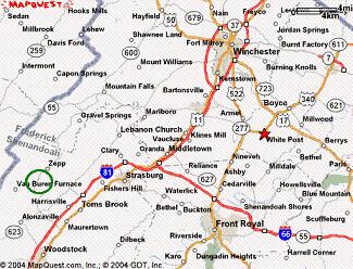
Green Circle Approx Location/Blue line WV border/Red Star Birth Place Peter Yoho
Green Box shows location in Increased Scale
|
|
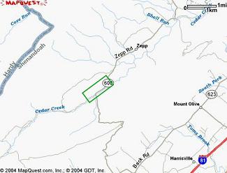
Green Circle Approx Location/Blue line WV border/Red Star Birth Place Peter Yoho |
Green Box shows location in Increased Scale |
Hugh Yoho of Sunland California has been an ardent Yoho history researcher for many years. One of his long time goals has been to find the land deeded by Lord Fairfax to John Yoho near Winchester VA in 1766. This land was sold by John to an Alexander Machir in 1771.
As a Civil Engineer by education, Hugh Yoho is well trained in survey techniques and the interpretation of survey information. He used his skills to find (with very high probability) the John Yoho land in present day VA. Hugh believes John Yoho to be the original immigrant Johannes Joho. For reasons I discussed in another section, I beleive this John was a son of Johannes. The truth may never be known. The deed and discussion can be viewed on another page of this site.
The location of John Yoho's land is presented in two parts:
| Written Account of Land Location by Hugh Yoho | |
| Pictures of Present Day Site by Bruce Willey |
On August 19, 1766, John Yoho obtained a Northern Neck of Virginia land grant from Lord Fairfax. This man is identified as Johannes Joho of Alsace France, born about 1712, the ancestor of almost all American Yoho's. Johannes and his wife, Susanna, arrived in Philadelphia, Pennsylvania in 1738 aboard the sailing ship, Two sisters, having originally embarked in Rotterdam, Holland. The land conveyance document grants a 246 acre tract on Cedar Creek in Frederick County, Virginia and includes a metes and bounds description of the property (bearings and distances along the tract lines with physical descriptions of the property corners). If John Yoho's birth year of 1712 is accepted, he would have been about 54 years old at the time of the land transfer.
On July 22, 1771, John Yoho sold this parcel to Alexander Machir and the Yoho family evidently then moved to what is now the Northern Panhandle of West Virginia. The description of the property in that land transfer documet is consistent with that given in the grant to John Yoho from Lord Fairfax. However, some believe the seller in this case was John, a son of Johannes Joho.
Where exactly on Cedar Creek was this property located?
In 1977 I drew a plat of the property using the described tract lines in he grant and was able to obtain sufficient information from that document to plot the probable location of Cedar Creek within the bounds of the property (Appendix C). I noted at that time there was an error in the closure of the traverse of the property lines. In other words, the last course of the traverse did not end at the beginning of the first course, a requirement for an accurate metes and bounds description. Using U.S. Geological Survey maps of the Cedar Creek area, I then attempted to pinpint the actual location ofthe property by superimposing on those maps a "to scale" transparency drawing of the property at various locations along the creek. An assumption was made that Cedar Creek had not appreciably changed its course over the years. Several locations were found where the plan of the property and the assumed creek location seemed to approximately fit the acutal course of Cedar Creek and surrounding terrain indicated on the maps, but the results were unconvincing.
Then in December, 2001 at the Southern Califonia Genealogical Society, I found reference to a 495 acre tract of land near Cedar Creek granted to Thomas Perry in 1753. This name sounded familiar and a rereading of the John Yoho land grant revealed the following description of the third course: "then S 28 E fifty six poles to a pine and white oak sapling by a steep bank of the creek, a corner to Thomas Perry." Of further interest was the fact that Thomas Perry's land was in both Frederick County and what is now Warren County (Frederick County was formed in 1738 and Warren County was formed from Frederick County in 1836). It seemed likely that, with a metes and bounds description of the Thomas Perry grant along with its relationship to Cedar Creek and the Frederick County - Warren County line, a reasonably approximate location of the adjoining John Yoho tract might be determined. However, a complication arose when I discovered in the "Abstract of Virginia's Northern Neck Warrants and Surveys" two additional properities that Thomas Perry had an interest in on Cedar Creek. At this point, I ordered updated U.S. Geological Survey maps of that area of Virginia and requested copies of the land descriptions of the Thomas Perry properities from the Virginia State Library.
The quality of a survey depends on the accuracy of the instruments and the experience, reliability and competence of the surveyor. The instruments of that day (probably only a magnetic compass, a simple device to read vertical angles, and surveyor's chain) were obviously more primitive than today's electronic equipment, which will measure lengths to a small fraction of a foot and angles to a small fraction of a degree. Additionally, surveyors of that period had to make mathematical calculations using tables of logarithms, a tedious and laborious process, resulting in many opportunities for error. It would not be surprising to find some of these surveyors taking mathematical "short cuts" or making approximations of distance and bearing while performing surveys for a largely uneducated public. I'm sure it never occurred to the surveyor, Robert Rutherford, that his work would be reviewed by someone two hundred and thirty six years later.
Out of curiosity, I calculated the area of the grant. It is noted that one pole equals 16 1/2 feet, and the terms "pole", "perch" and "rod" are interchangeable. One acre equals 43,560 square feet. The calculations result in an area of 218.97 acres, a sizeable difference (11 percent less) from the 246 acres cited in the land grand document. Because John Yoho paid Lord Fairfax the fee rent of "one shilling sterling money for every fifty acres of land hereby granted and so proportionable for a greater or lesser quantity", he appears to have been taken on this particular land transaction.
By February, 2002 I had received the maps from the U.S. Geological Survey and the surveys for the three Thomas Perry properties. It was immediately obvious that the survey for property number 3 was the parcel that adjoined John Yoho's land.. I attempted to interpret all the information in the survey an then drew a sketch of the two properties along with their relationships to Cedar Creek (Appendix K). Of great interest was the statement in the survey saying this land is on a branch of Cedar Creek that drains from Littles Gap. The wording in a related document, directing the surveyor, Robert Rutherford, to survey the Thomas Perry property, indicates the mouth of this branch lies within the bounds of the property. However, I was unable to find the name, Littles Gap, on the U.S.G.S. maps.
Using a "to scale" transparency showing both properties, I once again tried to find a good fit of the parcels and their descriptions with actual map locations along Cedar Creek and its adjacent terrain from its source just north of a saddle connecting Little North Mountain and Little Sluice Mountain to its outlet into the North Fork of the Shenandoah River near Strasburg. On the U.S.G.S. map titled, Woodstock, I found a location, in what is now Shenandoah County (In 1772 Dunmore County was formed from Frederick County, and in 1777 Dunmore county was renamed Shenandoah County), westerly of little North Mountain near the Cedar Creek Church, at the junction of State Routes 600 and 713, that seemed to satisfy almost every condition stated in the two property surveys. Here, two northerly flowing streams, tributary to Cedar Creek, cross the suspected location of the John Yoho and Thomas Perry properties, and it seemed that either one could qualify as the "branch of Cedar Creek that Draines Littles Gap".. At this point I wrote letters to St. Vincent Luthern Church and St. Peter's Luthern Church, both located in Toms Brook, Virginia and not too far distant from the suspected property location, requesting assistance in locating Littles Gap. I did not mention Sheffer Gap in those letters because I had not yet noticed it on the map. I also wrote to the Virginia State Library and the Shenandoah County Library, this time mentioning Sheffer Gap, with a similar request.
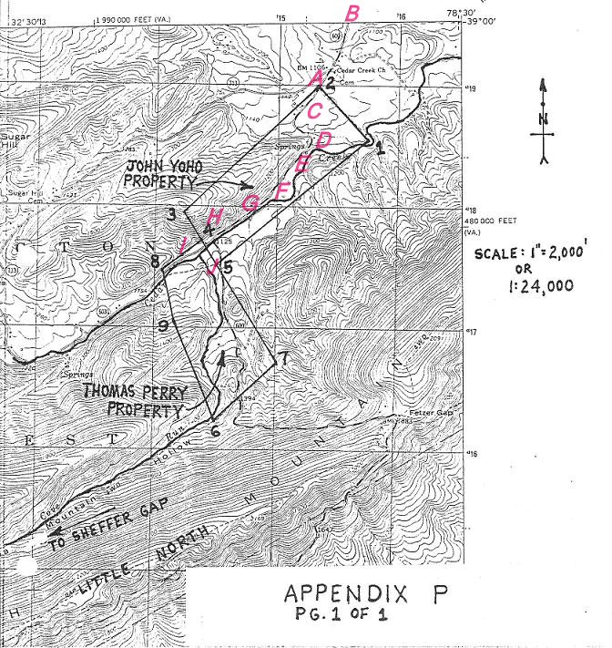
By late March 2002, I had still not received any information regarding the location of Lttles Gap. Neither the Library of Virginia, the Shenandoah County Library, nor St. Peter's Luthern Church had information regarding this landmark, but all three agreed that geographical names were often changed as land passed from one family to another. I therefore decided to conclude my search by showing on the U.S.G.S. map titled, Woodstock, a location I very strongly feel is the site of the John Yoho land grant (Appendix P).
Incidently, while waiting for information on Littles Gap, I found in the book, Pioneers of Old Frederick County Virginia by Cecil O'Dell, reference to a 1755 will witnessed by John Tipton and Johah Little.. Now, a John Tipton was named in the Thomas Perry Survey and was also a chainman on that survey, which refers to Littles Gap. Is there a connection between Johah Little's family and Littles Gap? Did John Tipton suggest to his boss on the survey party, Robert Rutherford, "Hey Bob, why don't we name that low point through the mountsins beyond the headwaters of this branch of Cedar Creek 'Littles Gap' after my good buddy Johan Little?". Or perhaps someone in the survey party said, "Why don't we call that gap up there 'Littles Gap' because its located near Little North Mountain?" These are questions I, of course can't answer.
On Appendix P, I show the boundaries of the John Yoho and Thomas perry properties, and have darkened both the north-east flowing Cedar Creek and Cove Run to make them more visible on the map. I have also numbered the property corners of both surveys for reference purposes. The scaled geographical center of the John Yoho property is 38 degrees, 59 minutes, 18 secons N. Latitude and 78 degrees 31 minutes 05 seconds W. Longitude.
I now set forth my reasons for concluding that Appendix P probably shows the correct site of the John Yoho land grant. I do this by citing the points of agreement between the U.S.G.S. map and the two surveys. The following locations refer to those numbered on Appendix P. Keep in mind, on a topographic map, the closer together the contour lines are, the steeper is the terrain.
1. Location 1, the beginning of the John Yoho survey, is on the northwest side of Cedar Creek (A stream flowing northeast has northwest and southeast banks)
2. Location 2 is on level ground.
3. Location 3 is on a high ridge
4. Location 4 is on a steep bank of the creek.
5. Location 5 lies across the creek from location 4
6. Location 6, the beginning of the Thomas Perry Survey, lies on the south side of a branch of Cedar Creek near a spur of Little North Mountain (Here, an inconsistency arises in that that the survey says this branch drains Littles Gap, and the map shows this branch, Cove Run, draining Sheffer Gap. Could it be that Sheffer Gap was at one time known as Littles Gap?)
7. Location 7 is by another spur of the mountain
8. Location4, common to both surveys, is by a steep bank o Cedar Creek and lies on the other side of the creek from location7.
9. Location 8 is at the base of a steep hill.
10. Location 9 lies across the creek from location 8 and is near a little valley, just to the west, that could be the "draine" referred to in the survey
11. The first course of the John Yoho survey, from location 1 to location 2, lies exactly along an existing unimporved road between Cedar Creek and State Route 600 and is almost the same in length. I suspect this is more than a coincidence.
12. The general configuration and course of Cedar Creek, within th bounds of the two properities, fit the descriptions of the creek in the two surveys, and the mouth of the branch of Cedar Creek (Cove Run) is within the limits of the Thomas Perry property.
13. Finally, using U.S.G.S. maps titled, Woodstock, Toms Brook, Mountain Falls, Middletown and Strasburg, I have examined the length of Cedar Creek from it s source to its outlet into the North Fork of the Shenandoah River, and have found no other location that comes close to satisfying the conditions of the two surveys in the manner that the site on Appendix P does.
My last thoughts in this matter: 1. I will continue to search for the location of Littles Gap (The Library of Virginia has given me some leads to explore) and will amend this document if I'm eventually successful. 2. Wouldn't it be interesting to actually visit this location in Virginia and perhaps try to find that "large rock stone on a high ridge" mentioned in the John Yoho survey? With the exception of the creek and the topographical features, that rock might be the last remaining landmark of those mentioned in the surveys, unless some of the trees, described at the property corners, have survived to this day.
I conclude with the words of Tim Yoho of Lock Haven University in Pennsylvania, another Yoho family historian interested in the location of the John Yoho property. In an email to me dated in March 2002, he states, "For those of us who like history, expecially family history, there is something special about knowing tangible things about our ancestors. It gives me goose bumps to think about someday walking the land that John once owned.".
Hugh L. Yoho
Sunland, California
March 29, 2002
![]()
Bruce Willey is from Springfield Virginia and was a roommate of Hugh Yoho at the University of South Carolina. I don't know Bruce, but knowing Hugh and the fact that he is from California, my guess is he promised Bruce a movie contract for his work. He certainly deserved it for his efforts and great photography. I can't give him an Oscar but being a scientist, I can nominate him for the "No Bull Prize".
A Portion of John Yoho's land may be pesently owned by Guy Brill who operates a commercial fish or "trout farm" on the property. Mr. Brill gave Bruce permission to walk his property and take photos. Bruce included a detailed description of photos and their location according to the Appendix that follows. Bruce completed his report with the following comment:
Hopes this helps give you some of the knowledge you have been seeking for so very long. I'm happy to have been a part of your quest and am ready to provide any further assistance you might need. If any of the other interested parties want to form a "search party" I'll be happy to be a part of it.
Bruce numbered each picture and related them to locations designated by "Letters" on Appendix P (below).
Numbers on the map are referred to as "Sites" . For additional reference points, note location of Cedar Creek Ch (Church) and Route 600(starts at "B") on the map.
 |
![]()