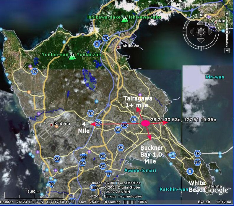
Coordinates: 26 21 30.53N, 127 51 19.35E
Since I began the PsyOp Page in 2004 I have wondered about the origin and the fate of the Deragawa Transmitter Site. The 16th PsyWar Company of which I was a member, first occupied the site in 1962. We knew the facility was built by the Air Force but did not know the specifics.
In 2005 I received e-mail from Jack Sokol and Dick Himes who had served at the site with the 13th Communications Squadron, 313th Air Division, 5th Air Force from 1955 to 1956. They sent a picture which had only two recogonizable buildings, Papasans house and Mamasans Store. The microwave tower was present at the site. The other buildings no longer existed when we arrived in 1962. More about that later.
Since 2004 I also received mail from others who served at Deragawa after I left in 1963. Some of those include: Chuck Skittino, Charlie Thrun, Scott Peacock and Jim D'Amato who have accounts in the History of The 16th Company.
Jim D'Amato said the 16th was deployed to Cambodia/Thailand in 1970. He indicated that Deragawa was occupied by the 18th Det when he returned in Feb of 1971 for his E5 test. He returned to the Thailand deployment and stayed until Dec 71 when he was reassigned to the 1st PsyOp at Ft Bragg.
Scott Peacock who was a PsyOp Information Specialist said in an e-mail of 3/20/06 that he served with the 16th in Thailand until 1973. He did not know how long the 16th remained in Thailand or what happened to Deragawa site. The fate of Deragawa was therefore not known from 1971 to 74 when the 7th was retired to the reserve Army.
In the summer of 2007, I began to wonder again about the fate of Deragawa and decided to use Google Earth Satellite Views to see if I could locate the area. My first reaction on seeing the "New" Okinawa in 2007 was one of total amazement and confusion. It appeared that someone had used a very large eraser and wiped the island clean and started anew. I did not recogonize anything except the outline of the coast, the large city of Naha and Kadena Air Force Base. Everything else was completely different. I did find Tairagawa, once a small village 1-2 miles from Deragawa. Tairagawa is now a fairly large city.
I spent hours looking for evidence of the site but found nothing that looked like a transmitter building and barracks. I decided to contact some of the previously named individuals and ask if they could help in trying to locate the area. Charlie Thrun remembered the village just outside the gates was known as Hauntabaru. Jack Sokol also remembered the village name and said it meant "House on a Hill" in Japanese. Google and Google Earth found no evidence this village which must have been a local naming. Chuck Skittino also remembered the village name and sent some additional photos which helped to reorient my memory to the former location.
Jack Sokol (Air Force 55-56) could not add any additional information to find the area. He said he had returned to Okinawa in 1992 but did not find the site. Dick Himes (AF 55-56) came though big time and actually pin pointed the location. Dick had also returned to Okinawa (in 1996) to look for the site. He said he had a good memory of the roads and elevations but at first could not find the location.. He had talked with a number of Okinawans who did not know of a former military base in the area of his search. Finally someone remembered an old man who did and he mentioned transmitter building and barracks. Turns out Dick was only a few blocks from the site and had not recogonized it. Nothing remained of the former buildings except for Papasans "compound" and building that served as Mamasans store just outside the former gate.
Finding that location with Google Earth turned out to be a bit of a problem for Dick, but with the use of a map his wife had drawn while they had visited in 1996, he eventually found the location. Based on pictures I provided and a hand drawing from Chuck Skittino, Dick made a sketch of the fenced in compound as well as the buildings in existance during my tour and possibly until 1974 when the 7th PsyOp Group was assigned to the reserves. It is also possible that Deragawa was returned to Okinawa in 1972 when Okinawa once again became part of Japan. I know that some US controlled property was returned at this time but do not know if Deragawa was part of that transaction. I would appreciate hearing from anyone who knows when The land and buildings of Deragawa were returned to Okinawa control.
It is interesting that some of the same roads are still in existance and can be recogonized in both 1960's photos as well as 2007 satellite shots.
Dick Himes and Jack Sokol answered my question as to the origin of the buildings our Company inherited in 1962 if not before.
Jack indicated the Microwave Tower was built in 1956 and that most of the other site buildings were destroyed by a Typhoon in 1956. Personnel were housed in the "Microwave Building" which may have become the Generator Building.
Dick explained the origin of the other "New" Buildings. In an e-mail dated 10/27/07 Dick Himes wrote:
I do not remember a mural in the Mess Hall but then my memory is in exponential decline. Does anyone else remember the Mural?Thought I would send maps of the Site boundaries & building layouts tonight, but that will be delayed until tomorrow at the earliest. It turns out that I burned up this evening discussing the dimensions of the Barracks with the person who designed & built the Barracks in 1957. YES - THIS IS TRUE!
I talked with George Wargo, who lives in Coaldale, PA. He was the NCOIC at the Site in late 1956 when I rotated back to the States. He continued as NCOIC until late 1958, and worked extensively with the Japanese Contractor who constructed the Barracks & MessHall in the summer of 1957. I had calculated the length of the Barracks at 140 feet, but he claims it was 150 feet. Not bad feedback from a retired career AF NCO at age 76. (my guess) He described the Barracks layout in detail, two-man rooms with wash facilities in the center of the building, also two one-man rooms for the top NCOs, an H-shaped building with MessHall attached. His description was very accurate, especially considering that he has lost all photos years ago. He said the funding for the Barracks & MessHall came from "typhoon money". Apparently, the design was sort of "back-of-the-envelope" in quick response to the destruction of most Site housing that occurred in the September 1956 typhoon. That typhoon (wind meter blew away at 149 knots) occurred prior to my leaving for the States. He also mentioned that he had commissioned a Japanese painter to paint a mural scene of the Site buildings (he sounded very proud of this) on the interior wall of the MessHall. Did that mural exist in 1963?
1. The first picture shows Deragawa as an Air Force site in 1956 during the tours of Jack Sokol and Dick Himes. The view is toward Buckner's Bay. The only buildings remaining in 1962-63 were Papasans House (Roof can be seen) and Mamasans house which served as a neighborhood store in the 50's and 60's and perhaps into the 70's. (1956 View)
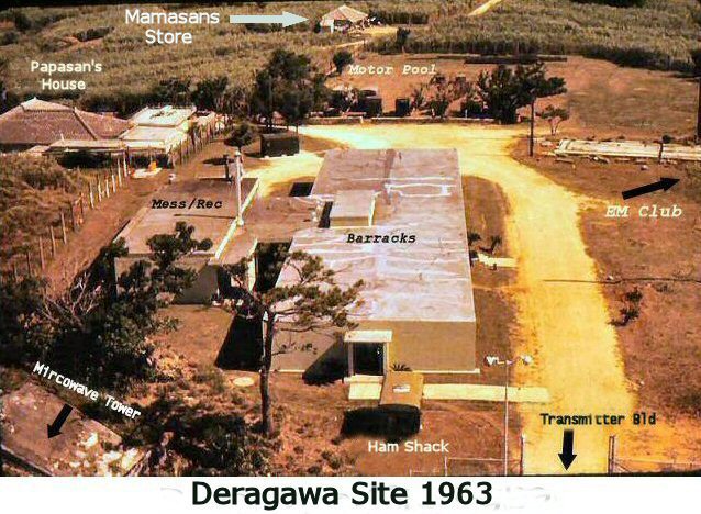
2. This 1963 view is in the same direction but now shows different site buildings than were present in 1956. Papasans house and Mamasans store are still present. (1963 View)
3. In 1966 the area looks the same except that Mamasans house is difficult to see.. (1966 View: Photo By Chuck Skittino).
4. Entrance to the compound in 1970 showing Jim D'Amato. Papasans house and compound is to right front of gate. (Entrance View)
5. Road Map (1996) used to mark Deragawa location by Dick Himes wife. Adjacent to map is satellite view and general location of site. (Map/Sat)
6. The location of Deragawa in 2007 can be viewed on Google Earth at position: 26 21 30.53N, 127 51 19.35E (Satellite location in Reference to overall view of Okinawa)
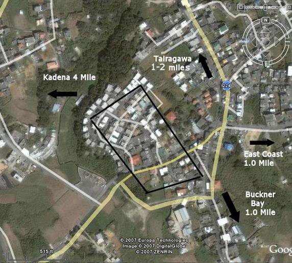
7. Satellite View of Location in Reference to Kadena, Buckner Bay, and East Coast of Okinawa
8. This 1963 photo taken from the microwave tower toward the east shows a key road to Tairagawa and a bend and fork in the road which was used in part to verify location of site in the 2007 satellite view. One branch of the road leads to the east coast which is about a mile away. (1963 East View Bend in Road)
9. Satellite Hybrid Map (2007) of Dick Himes showing bend/fork in road. (Himes Map-1)
10. 2007 satellite view toward the east showing same bend in road toward Tairagawa and road toward the east coast. (2007 satellite Road Bend/Fork)
11. 1963 view of site showing location of buildings in the compound. Papasans house is out of the picture in lower right corner of photo. Part of the motor pool is visible in lower left of picture. (1963 View North)
12. Site Map drawn by Dick Himes using Satellite hybrid satellite image. The fenced-in compound encompases about six acres. The antenna fields were outside the compound. NOTE: The back entrance to Tairagawa was not present in 1962 or 1966. See photo below (#5) in Addendum (Himes Map-2)
13. In the last picture, I used above drawing by Dick Himes to add features to satellite image of the Deragawa site as seen in 2007. The main entrance is shown by white arrow next to Papasans house and compound ("PC"). Image shows back "gate" which was not present in 62-66. (2007 Deragawa Site)
Finding Derawaga has fulfilled a many year quest. I wish to thank all of those who helped in this search and especially Dick Himes who found the specific site on Google Satellite photos. Any comments, corrections, and additions are welcome.
Please see other accounts of Deragawa on the 16th Page.
1. Papasan also known as "Toddy" was a cook at Deragawa. Bull fighting was a big sport on Okinawa during our tours. Papasan took great pleasure in entering his bulls in fights. This is a picture of Papasan (on right) with one of his prized bulls. Photo submitted by Chuck Skittino (Papasan and Bull)
2. Photo of Okinawan kids at Mamasans store in 1966-67. Submitted by Chuck Skittino. (Mamasans Store and Kids)
3. Corner Market in Tairagawa 1966. Submitted by Chuck Skittion (Market)
4. "Cubetainer" used as a motorcycle garage in 1966. Mess Hall and Barracks can also be seen with microwave tower in background. Submitted by Chuck Skittino. (Motorcycle Garage)
5. 1966 View of "Dayroom" Club toward South. Location of former "Back Entrance" is labeled. This entrance was also not present in 1962-63. When passes to town were not available, anyone who wanted to just climbed over fence or through a hole that was present in 1963. Submitted by Chuck Skittino (Dayroom/Back Entrance)
6. This photo (by Chuck Skittino) of transmitter building and barracks in 1966 brought tears to my eyes. In the foreground is the company mascot Karen who I did not know was still alive and still a mascot of the 16th. We found Karen as a puppy in a Jeep engine compartment after a typhoon named Karen in 1963. She made a yelping noise as Jay Eubanks started the engine. I believe she lost the tip of her tail as a result of being hit by the jeep engine fan blades. The next picture shows me holding Karen in 1963. (Karen/Transmitter Bld)
7. Picture of me (Tim Yoho) holding Karen in 1963 as a puppy. Picture taken in compound by Al Maza. (Tim Yoho and Karen)
8. Al Maza in 1962 standing at entrance of Papasans Compound near entrance of transmitter site. (Papasans-Maza)